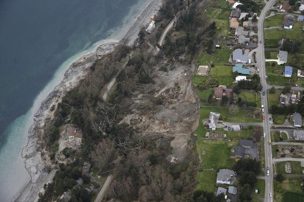
Perkins Lane, in Seattle’s Magnolia neighborhood, is notorious for its landslide risk. In the winter of 1996-97 — about six years before Landerholm would build his residence up the street — a landslide took out a half-dozen homes. Back-to-back wet winters had saturated the hillside.
Although the landslide threat has been known since Perkins Lane’s construction in the 1930s, it still hasn’t dissuaded people from building and living there. A quiet community, tucked away on a winding, narrow road along the Sound, thrives today with luxury homes.
“It’s not for the faint of heart — you think about [the risk],” acknowledged Landerholm, who has been building homes in Seattle for three decades. But, he added: “It’s a pretty damn nice place to live.”
It’s a trade-off Landerholm said he’s willing to make. And it’s one that more and more Seattle area residents are embracing as the region booms with newcomers and continued growth. While Perkins Lane is an extreme example, the Pacific Northwest’s undulating terrain and fair share of coastal bluffs mean there are countless plots of land designated as having “steep slopes” potentially at risk of landslides.
To ensure new development — or redevelopment of existing structures — is done safely, state law leaves it to local municipalities to set their own laws. The state Growth Management Act of 1990 told communities to designate “critical areas” and regulate their land use accordingly: environmental protections in the case of aquifers, wetlands or habitat conservation areas, or risk-management safeguards in the case of certain specific geological hazards, such as steep slopes at risk of landslides.
Just because a landslide hazard exists, though, doesn’t mean a slide is imminent or guaranteed to happen.
“You really can’t forecast or predict landslides. It’s a very difficult exercise,” said Stephen Slaughter, the landslide hazards program coordinator with the Washington Geological Survey. “Landslides are the most poorly understood geologic hazard. We know that rain is a trigger. We know that steep slopes contribute.
“It may not occur in our lifetimes and it may not occur in a thousand years, but there is a risk of landslides on any slope,” he added.
Much of Seattle, such as Queen Anne and West Seattle, has already built out in the shadow of that unavoidable reality, so it’s not practical to simply get out of the way of Mother Nature’s forces. Instead, geologists and urban planners urge education and awareness, so homeowners know the risks of landslides and how to prevent them, as much as is possible.
As the demand for new housing grows, though, there’s a new factor: Builders are willing to accept more risk and are moving their work into areas they previously shied away from — these geological “critical areas” once deemed too complex to build on but now considered worth the investment to stabilize.
“All the easy parcels are gone — they’re already developed,” said Christy Carr, senior planner for the city of Bainbridge Island, where a 1997 slide killed a family of four. “The ones that are troublesome with these encumbrances or critical areas or things that make it difficult or unsafe, that’s all that’s left to build on. It’s not uncommon at all.”
Washington state’s unique topography and geology makes it ripe for a variety of natural threats — from floods and wildfires to dangerous lahars from nearby volcanoes, like Mount Rainier or Mount Baker. But the state’s rugged terrain makes it particularly susceptible to landslide hazards.
Washington is one of the most landslide-prone states in the country, the state Department of Natural Resources (DNR) says. The Washington Geological Survey has an inventory of more than 58,000 known landslides in it — and that accounts for records from only about 10 percent of the state that the agency has systematically mapped so far, Slaughter said.
Slaughter’s team is in the process of mapping out the entire state using LIDAR technology, which creates a high-resolution topographic image of the Earth’s surface. That can give state and local officials a better idea of what areas might be susceptible for future landslides and “help people make better decisions,” he said, as opposed to relying on outdated maps and firsthand accounts of previous landslide occurrences.
Pierce County is one of the areas the state DNR has finished mapping and the resulting work actually revealed “much less risk than we’d built our map on previously,” said Mitch Brells, the county’s development engineering manager.
He said the new maps remove about 40,000 parcels from areas the county had previously designated as needing additional scrutiny for building permits and construction, because of the potential landslide risk. “To us, that’s good news because we don’t like permitting if we don’t have to,” he said.
In Seattle, city officials have a couple initiatives of their own to update local landslide maps, along with the DNR’s help through the new LIDAR technology. The city has been keeping landslide records since the late 1800s, said Susan Chang, Seattle’s geotechnical engineering group supervisor.
“By having a more accurate map, when people come in for permitting, we’re able to say with more accuracy whether or not they’re likely to have a landslide hazard area on their site or not,” Chang said. “And that determines the permitting path and how much scrutiny it gets.”
Municipal planners and builders say that if a piece of land is at risk for landslides, it doesn’t necessarily mean that it can’t be built on. Rather, it triggers more intensive review for building permits and geological assessments to ensure that whatever is built there is safe and doesn’t pose a risk to neighboring properties on a hillside.
“It’s pretty uncommon to find you can’t build there at all,” Pierce County’s Brells said. “Sometimes they have to do mitigation to eliminate the risk.”
That can simply mean removing water from a hillside by funneling it through a trench or pipe. But the requirements can be much more complex. “In some cases, a special foundation design is necessary — like putting a house on soldier piles or needle piles,” Brells said. “That’s a common thing we see.”
Landerholm said building his home on Perkins Lane “was the most difficult project I’ve ever done in my life” because of the engineering involved. To build into the hillside, he said, he had to drill 17-foot piles and also use I-beams for stability.
Today, there’s at least one new home under construction on Perkins Lane, and a handful of properties are listed for sale on the street.
“We call it the Malibu of Washington,” John Wellman, a broker who owns four of Windermere’s local real estate offices, said in reference to the waterfront city in Southern California known for its relaxed, upscale lifestyle. “It’s quiet. It’s the most tranquil place in the city, and as we grow and expand, people are really taking a second look.”
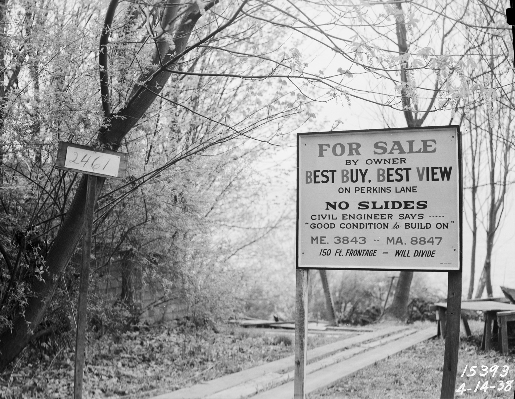
The landslide risk at Perkins Lane has been known since the 1930s, DNR’s Slaughter said, and yet developers built a slew of homes on the bluffs anyway, drawn by the spectacular views. A photo from 1938, kept by the Seattle Municipal Archives, boasts of a “best buy, best view” deal on Perkins Lane and falsely warned prospective buyers of “no slides. Civil Engineer says ‘good condition to build on.’ ”
“People are willing to live on steep slopes, like the Puget Sound bluffs, where they trade beautiful views for their personal safety,” Slaughter said. “Living on these bluffs — these bluffs are steep and they calve material regularly, and people are willing to take that risk to have those beautiful views in the [expectation] that ‘well, hopefully it won’t happen in my lifetime.’ ”
Landerholm acknowledges the risk but he comes at it from a different perspective, given his builder’s experience. “You can engineer around most of the critical areas issues,” he said.
Landslide hazard areas and steep slopes “are way, way, way safer after construction than they were previously because [the city is] asking for more stringent engineering and construction practices to pin those buildings down better and reduce the risk, by either strengthening the building or reducing the amount of water that gets into the hillside.”
“From a practicality standpoint, the best thing we could do is pave over every one of those steep slopes — but politically you can’t do that,” Landerholm said. “With paving, you could take all the water that would be a trigger and stick it into a pipe. If you got a gun with no bullets, it's not going to go boom.”
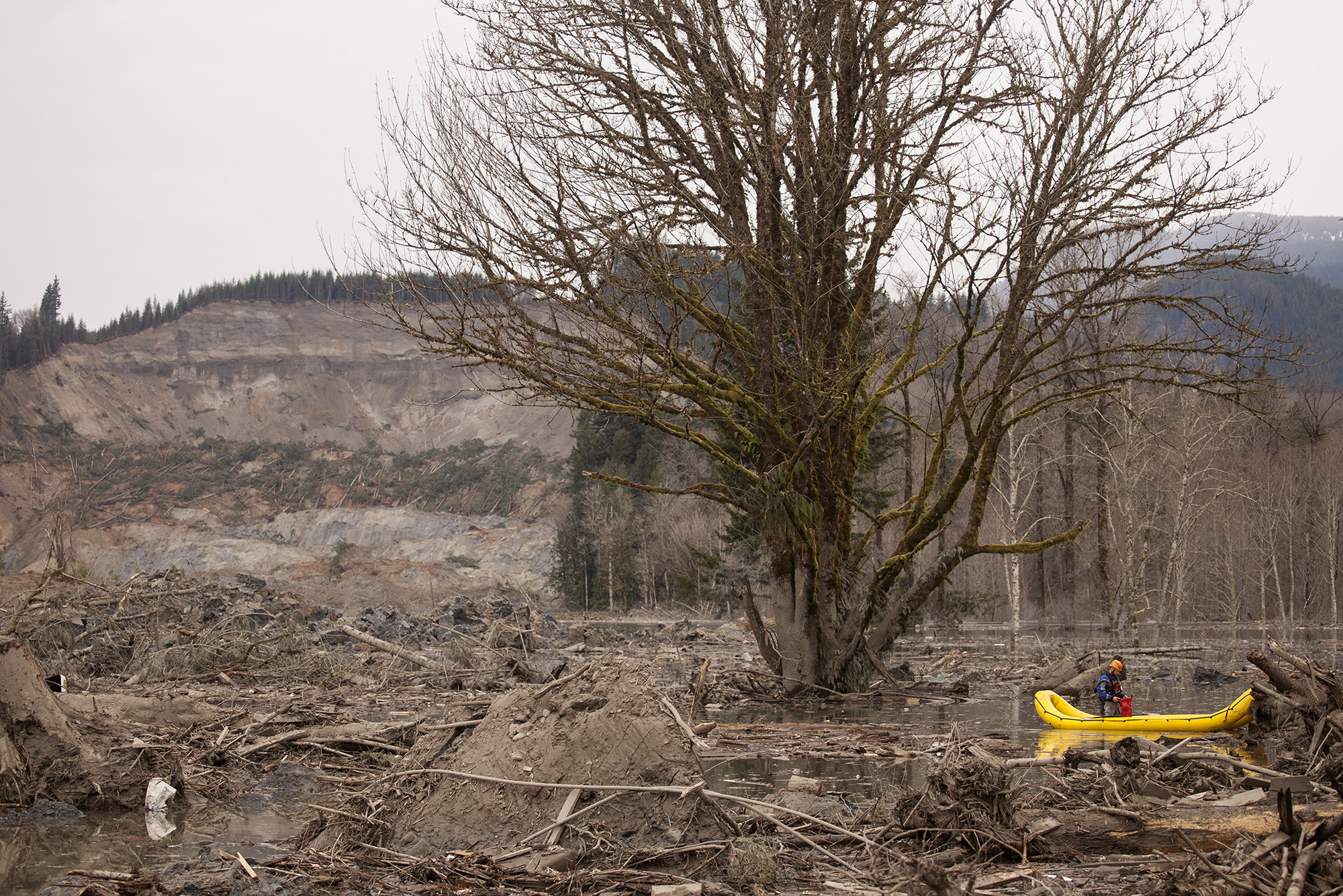
Geologists and city planners have looked to past landslide disasters to learn lessons for the future. After the deadly Oso slide in Snohomish County four years ago, local leaders adopted new regulations for their critical areas with greater setbacks and buffers near landslide hazard areas.
The winter of the Perkins Lane slide, Seattle saw more than 300 landslides, which prompted a task force and an extensive study to assess the city’s risk. Since then, the city has seen a decrease in slides, from roughly 10 to 20 per year about five years ago, to just about five a year in the last few years, said Bryan Stevens, customer service manager for the Seattle Department of Construction and Inspections.
“I really think that with the small number of slides we see each year, even in years where we see heavy rains, it means the regulations and the way we carry them out are effective,” Chang said.
Meanwhile, Bainbridge just updated its critical areas ordinance, and Carr, the city planner, says the trend is toward buffers “getting bigger or staying the same.”
“The bar really is safety — not only safety for you and your family and your structure, but it can’t create slope instability for neighbors,” she said. “It’s somewhat controversial ... there’s a perspective that they shouldn’t be able to get that close to the top of the steep slope and why would the city allow that? I hear that from people. But people who want to buy these properties want to do with them what they want to do and optimize the view. It is a tricky topic. It is a reasonable use of someone’s property and ‘reasonable’ is subjective.
“Obviously, it’s a risk,” Carr added, “and some people are more OK with that risk.”