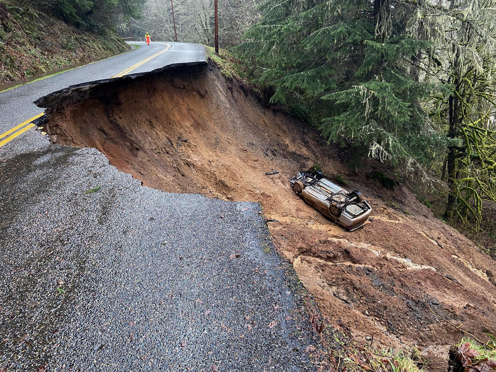
The car dodged puddles as it headed toward the place where a landslide had taken out a lane and left an approximately 15-foot-deep crater. Peterson realized that the driver didn’t see the danger. He began to run, crossing his arms to signal the driver to stop. He met eyes with the driver.
“Right at the end he could tell,” Peterson says. “He flew right into it, no slowing down.”
Peterson jumped into the ditch to help the driver escape from the overturned vehicle and get back up to the road. The driver, a local handyman, had a cut on his head, but otherwise emerged unscathed.
The unstable slope that cratered Fairfax Forest Reserve Road in Pierce County isn’t the only recent landslide to cause danger, delays and logistical headaches for residents of Western Washington.
Washington State Department of Transportation crews have been monitoring or responding to upwards of 20 landslides blocking roadways in the early part of February. East of Ashford, a town on the way to Mount Rainier, a slide across State Route 706 blocked access to the park’s Nisqually entrance and trapped residents between the debris and the closed park for five full days. Four separate slides fell onto SR 410 over three days, temporarily closing the highway into the town of Greenwater. And that’s just on state highways.
Private or county roads, like Fairfax Forest Reserve Road, are not maintained by WSDOT and don’t get counted in that tally. Pierce County has erected barricades so other drivers don’t end up in the ditch, but the county expects the road to be closed “for the long term.”
For Peterson and the dozen residents who live behind the damaged portion of the road, getting out initially required some creativity. Fairfax Forest Reserve Road branches off from SR 165 and ends at the Mowich entrance to Mount Rainier National Park, and residents who live along it don’t typically have another way to access the rest of the world. In order to get home those first few days, Peterson had to park his truck at a neighbor’s house, walk across the washout, and have his grandparents pick him up on the other side.
“Some people up here are trapped,” local resident Jill Cartwright said last week. A reopened dirt logging road now provides Cartwright and her neighbors outside access.
More rain, more landslides
“Landslides are a conspiracy of climate, geology and water,” explains Gabe Taylor, engineering geologist with the Headquarters Geotechnical Office at WSDOT.
Taylor usually works on engineering design and construction projects, but when heavy winter rains arrive, his additional duties involve responding to landslides that block roadways.
Deep-seated landslides — the kind that begin in bedrock — can be caused by glacial retreat or other slow geologic processes, but the vast majority of slides that Taylor’s office responds to are the shallow kind, which are also called mudslides and tend to happen during floods. When the soil is already saturated from a winter’s worth of rain, sudden and intense storms provide the trigger that causes unstable slopes to slide.
Washington is one of the most landslide-prone states in the country, and Western Washington’s steep slopes and wet weather put it especially at risk. This January was the fourth-wettest in state history and was followed by a set of February storms intense enough that Lt. Gov. Cyrus Habib declared a state of emergency in Western Washington on Feb. 5.
Those sudden storms are only expected to get worse as the climate shifts, making the Pacific storm belts known as “atmospheric rivers” more frequent. By the end of the century, the most intense daily rainstorms in Western Washington are expected to bring 22% more rain.
“The models are pretty clear that at least for our region, those atmospheric river events will become more common,” says Guillaume Mauger, research scientist with the University of Washington Climate Impacts Group.
Climate science can’t fully explain the future behavior of landslides; there are too many variables for scientists to have a clear sense for what will change. But “the one thing that’s pretty straightforward,” says Alison Duvall, assistant professor of earth and space sciences at the University of Washington, “is that more water, more intense water, more fire, or more intense logging is tipping things towards the abundance or increase of landslides.”
In 2011, WSDOT’s Climate Impacts Vulnerability Assessment Report found that climate change is expected to exacerbate current problems with flooding, landslides and coastal erosion. WSDOT does not keep track of the number of landslides on state highways, but it has identified some state routes as being more vulnerable than others to extreme weather events. County roads like Fairfax Forest Reserve Road aren’t included in the assessment.
Some of the most vulnerable highways are those in the mountains and at the base of steep slopes. SR 20, for instance, which runs adjacent to the North Cascades and closes for winter because of snow, might be closed just as often in coming decades even if the snow disappears. According to the report, fewer snow closures “may be offset by an increase in landslides because of rain events on slopes that are not protected by snow.”
Climate change will affect much of SR 410, too: Running parallel to the White River on one side and the Naches River on the other, the road is highly susceptible to flooding, high winds and slides.
“Everyone that I talk to at the closure is understanding — especially the people that are familiar with the area,” says State Trooper Rick Johnson, after responding to slides that blocked SR 410 near Greenwater. “There’s been slides there before, but the local residents are pretty resilient.”
“All of us pretty much know each other,” says Greenwater Fire Chief Paul Sowers. “We send out the call via word of mouth that we need some help filling sandbags.”
Although the highway was officially closed from Feb. 6 to Feb. 10, Sowers noted that a path had been cleared by Feb. 7 for medical emergencies. During the closure, Sowers kept the community updated via Facebook posts and led convoys out of the area for those who needed to buy groceries.
At the same time, further south, a landslide across SR 706 cut off Dennis Day and the other residents of a small neighborhood just a few hundred yards west of the Nisqually entrance to Mount Rainier National Park.
“The main thing that we’re doing is knocking on doors,” says Day, a volunteer firefighter and fire commissioner of Lewis County’s Fire District 17. A number of the area’s residents are in their 80s, and some people who weren’t physically able to serve as first responders nevertheless pitched in as volunteers, showing up with shovels, trucks and backhoes.
“This is the most flooded I've seen it,” Day says.
He calls his neighborhood an “island community”: While technically part of Lewis County, the people there are almost entirely dependent on neighboring Pierce County Fire District 23 for emergency services. The Lewis County seat of Chehalis is about two hours away in ideal conditions, so Day emphasizes that it’s the responsibility of people who live there to check in on each other.
“We don’t all have to go to each other’s birthday parties, but we have to make sure the roads are open,” Day says.
Ultimately, the response to the SR 706 slide brought together local residents, WSDOT emergency response teams, volunteer firefighters from two counties, Pierce County Emergency Management, the Forest Service and Mount Rainier National Park.
Matt Medford, fire chief and only full-time employee of Pierce County’s Fire District 23, says that keeping the community safe would have been more complicated without Mount Rainier National Park as a neighbor. The park has its own law enforcement and emergency services staff, and they offered emergency medical treatment to any residents outside the park boundaries who had been isolated by the slide.
In the mountains of Washington, the road network can be sparse, leaving some communities with only one way in and out. A 2014 Forest Service report on Climate Change Vulnerability and Adaptation in the North Cascades noted that on the roads around the North Cascades and Mount Rainier “the loss of a segment of trail or road can leave large areas inaccessible for long periods depending on the extent of damage and availability of resources for repair.”
The road network through Washington’s mountains is largely inherited from 19th century routes that took the easiest way across the passes. Because terrain limits highway routes, the roads often follow the path of least resistance through valleys or low points. Gravity, water and mudslides follow that same path.
“Because we have beautiful mountains and lakes and the Sound, we have a very tricky and narrow corridor of transportation,” says Duvall. “Our rail and many of our road corridors are in the most landslide-susceptible positions.”
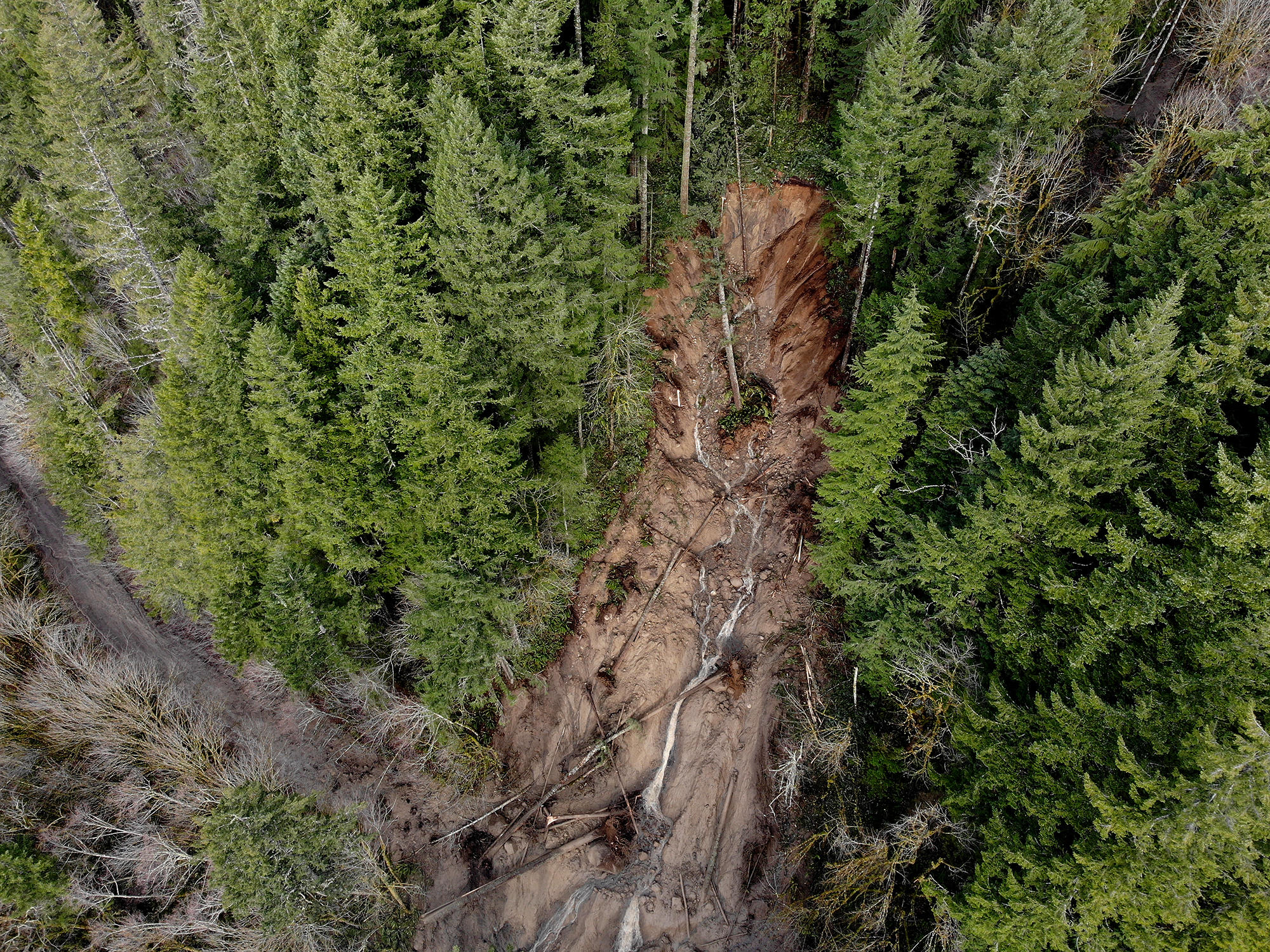
A landslide above SR 706, east of the town of Ashford, closed the "road to Paradise" to all traffic on Feb 6, 2020. (WSDOT)
'It could hit you'
After the 2014 Oso tragedy killed 43 people near Darrington, the state Department of Natural Resources received funding from the Legislature to do a LiDAR scan of the entire state to evaluate landslide risk. Where landslides have happened in the past is the best predictor of where they’ll happen in the future. Risk maps are being completed county by county and are currently available for King and Pierce counties and along the Columbia River Basin. Results for Whatcom County are due next month and Snohomish County will follow in the fall, but a timeline for completing the rest of the state remains undetermined.
The scans found that 24% of the major roads in Pierce County are routed over areas with moderate or high susceptibility to shallow landslides. In King County, landslides are most frequent along the bluffs overlooking Puget Sound, in river corridors and in the Cascades.
Although Seattle and King County have a robust transportation network and lower odds of isolation by landslide, the possibility is real. More than 8% of Seattle’s surface is considered landslide-prone, and the city’s Office of Emergency Management recognizes that when landslides block roads, it can “inhibit the city’s ability to deliver critical services to impacted neighborhoods.”
In the Monroe area's Skyview Estates neighborhood, the only road into the community was partly destroyed by slides two weeks ago. In King County’s Fall City, residents are being asked to voluntarily evacuate because of a slow-moving slide on the only road of access.
The isolation from slides can leave unexpected damages even for communities that have alternate routes out. Darrington Mayor Dan Rankin says that when a slide on SR 530 cut the town off on March 22, 2014, the alternate route added an hour and a half to most everyone’s commute.
“We were reconnected with a real highway at the six-month mark,” Rankin says. “Social [and] economic impacts were substantial and long lasting.”
In mountain towns, natural hazards like these are common and, according to Fire Chief Medford, some people who were affected by the slide on SR 706 already had access to generators or solar energy.
“For the folks who live out in my neck of the woods, it’s roughly an hour to a major chain grocery store, and I think they’re a little more in tune with getting cut off and having supplies,” Medford says. But he urges even residents of even bigger cities to prepare by having extra food and medicine on hand.
“The folks that are in the suburbs may not always think about that because they’re fortunate to have a good infrastructure,” Medford says. “But it could hit you.”
Cartwright, the resident of the Fairfax Forest Reserve Road area, says she and her neighbors off of the road didn’t worry much after its collapse.
“Half of my neighbors are on solar power and hydroelectricity; we have a landline phone — we’re very self-reliant people,” she says. “I’m not fearful or anything. A lot of us have chickens, I have fresh eggs. I’m making chicken noodle soup.”