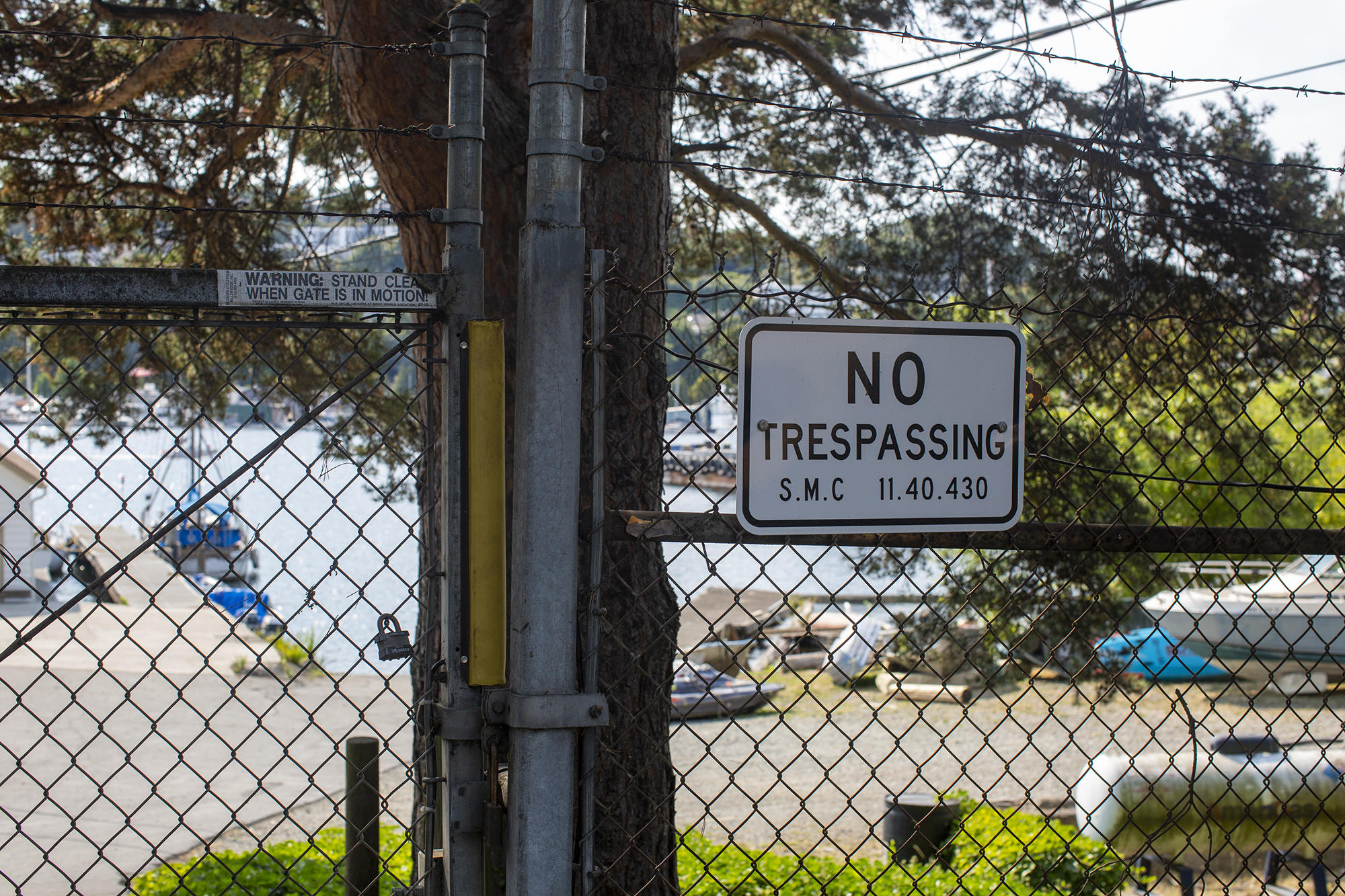
Seven years ago, Hunter and Raaen, then both board members of the Wallingford Community Council, submitted an application asking for public access to this little strip of land and water that lies behind a “No Trespassing” sign on the fence surrounding the Harbor Patrol headquarters. Waterway 20 is owned by Washington state and managed by the state Department of Natural Resources, but the Harbor Patrol has been using it since 1962 as a storage spot for floating debris the patrol picks up from Lake Union.
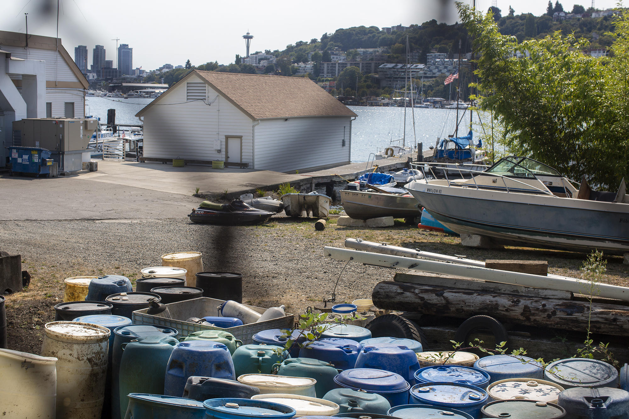
Right now it doesn’t look like much: Behind the barbed wire fence are blue barrels lined in uneven rows with invasive blackberry growing between them. There’s also a small dilapidated pier, as well as a screen of bamboo separating land from water. Derelict boats, buckets and logs are scattered throughout the area. Every once in a while the U.S. Army Corps of Engineers comes by with its huge snag vessel, the Puget, to collect the debris and take it away.
But Hunter, who along with Berkedal still serves on the Wallingford Community Council, sees other possibilities. He pointed to where he envisions kayak storage lockers could go.
“That particular waterway is designed for access by hand-carried boats, kayaks and canoes,” says Raaen, “because a lot of times the waterways are right up against a drop off, but here you’ve got a lot of land, a gentle slope, it’s centrally located and very close to Gas Works Park.”
Fifteen years ago, the council had even bigger dreams. In the Wallingford Neighborhood Plan of 2004-2005, neighborhood leaders called the waterways “precious public resources” for both public recreation and salmon migration. Of Waterway 20, they wrote: “This location could serve as one of the city’s primary nonmotorized boat launches accessing Lake Union. With additional space, a sailboat rental and school could be incorporated, as proposed by Friends of Gas Works Park.”
Twenty-three waterways dot the perimeter of Lake Union, nine of them on the lake’s north shore. They were established more than a hundred years ago when the Montlake Cut opened and connected Lake Union to Lake Washington. Those days, boat travel was the primary way to transport goods, and the waterways were an early relative of interstate offramps — places where people could get their logs or pigs or cows into and out of the water. (These “waterways” are not to be confused with the generic term referring to a route by water, like a canal. In this context, they refer to specific state-owned water access points).
Legally, the boat-paddling public is supposed to get first priority when the state decides how waterways are used. The Department of Natural Resources can permit private parties to use the waterways for other reasons for a fee, but the Seattle Police Department has never had a permit or paid the state for access.
The city of Seattle does own the land next to Waterway 20, where the Harbor Patrol’s headquarters are located, and this isn’t the first time that an adjacent landowner has blocked public access to a waterway. As cars became the main mode of transportation, the waterways were somewhat forgotten, and in many cases they’ve either been subsumed by invasive plants or cared for by property owners nearby who benefit from extra pockets of shoreline.
The six waterways we viewed on our brief afternoon walk were in varying states of accessibility. I met Raaen, Hunter and Berkedal at Waterway 15, a beautifully maintained small park next to Ivar’s Salmon House. When I approached, Hunter asked with a laugh if I knew it was them because they were three old white guys standing together. It was relatively busy, with people sitting on benches and talking with friends; Raaen said to keep this place in mind as a vision for what the other waterways could be.
At Waterway 16 two blocks away, there’s no waterfront access — just a drop-off and a lot of giant boulders. A construction company is using the area as storage. At Waterway 17, broken pieces of asphalt stuck out of the water, while two otters played nearby. Waterway 18 was restored with help from the Seattle Parks Foundation in 2010, and Waterway 19 is currently off-limits to the public because of toxic chemicals leaching into the water from Gas Works Park.

Alisa McKenzie watches her cousins from the shore of Waterway 18, as they play in Lake Union, September 4, 2020. (Shaminder Dulai/Crosscut)
Walking on waterways
Over the years, Hunter and Raaen have guided their Wallingford neighbors on annual walks like this along the shoreline to raise awareness of the public access that’s available — and the kind of access they see as written into law, but not protected by the city or state.
The legal status of the waterways has special resonance to the two men, both of whom are attorneys at Sound Law Center and have spent their careers specializing in land use and environmental issues. Hunter served as legal counsel for the Washington state Legislature for five years and helped draft the State Environmental Policy Act and the Shoreline Management Act. As we walk, Raaen recounts the battles over sidewalks on Northlake Way, tells the story of the Wallingford Steps’ creation, and explains that Tableau Software technically has to let the public have access to the rooftop of its building on North 34th Street as “view mitigation” for being so tall that it blocks the sight of the lake.
“Before COVID, we used to have a waterway walk, where we’d tell the public about all the litigation and fights over the years,” says Raaen. “There’s a lot of public access available that the community doesn’t even know about. It’s an ongoing problem along the waterfront that the Wallingford Community Council has taken a very strong interest in.”
The Harbor Patrol declined to be interviewed and directed questions to the Facilities and Administrative Services Department (FAS), the city department responsible for real estate. Although Harbor Patrol leadership has had documented meetings with FAS about this issue since at least 2014, it’s unclear whether all the officers who work there know about it. The officer who let us in the gate seemed skeptical when I told him that these were representatives from the Wallingford Community Council, and we were on a tour of the public waterways on the north side of Lake Union, including this one. When Raaen said the Harbor Patrol is supposed to be meeting with the community council to develop a plan for public access, the officer said he wasn’t sure how that would work.
In theory, the Harbor Patrol could keep storing trash there while letting the public have access to the water. But until recently, the city department responsible for securing a waterway permit hasn’t shown much interest in sharing. In March 2013, the city filed an application with the Department of Natural Resources requesting that the Harbor Patrol retain “exclusive use” of the space. That came after the city met with the waterway’s next door neighbor, the Center for Wooden Boats, and learned that it hoped to use the space, too.
Just a few weeks later, Hunter and Raaen filed their competing application.
Waterway 20 lies behind a fenced area controlled by the Seattle Police. The area is typically used to store debris that the Harbor Patrol picks up from Lake Union. (Shaminder Dulai/Crosscut)
Toxins and trash
In the negotiations that have taken place over the past seven years, the Department of Natural Resources has had to grapple with both the concerns of those looking for access and questions from the city of Seattle and the U.S. Army Corps of Engineers over public safety. If the public gets to use Waterway 20, where will the flotsam littered across the site go? Is there another place where the Harbor Patrol could store that stuff before the Army Corps comes to pick it up?
In a 2017 email to Nancy Stachey, the real estate manager with FAS who has overseen the permit negotiations for the city, the Army Corps’ Brad Schultz wrote: “The optics in the area are that this is just a floating junk pile, but the actuality is all of the debris and derelict vessels were floating in the Puget Sound and Lakes and were found adrift.”
Currently, the Harbor Patrol is the only entity that has a place to put those floating logs and debris, which could hurt boaters who might run into them. Schultz asked that the Harbor Patrol either be able to keep using the area or come up with an alternative storage plan.
“This pen is the only one near Seattle, and the loss of this pen without a replacement storage area could hamper our debris mission and could directly impact the safe navigation of commercial and recreational boaters in the Seattle area,” Schultz wrote.
Stachey did not respond to a phone call requesting comment.
Still, there’s the question of whether, like Waterway 19, the area is too contaminated by chemicals for the public to use.
It’s unclear to what extent the city has been asking this question in good faith. Gas Works Park is already the site of an existing clean-up effort by the state Department of Ecology to remove the toxins left by the gas plant’s 50 years of operation. But the city hasn’t included Waterway 20 in these clean-up efforts, which are happening only a few hundred yards away.
The issue of contamination hadn’t been mentioned before Wallingford residents sought public access. Similarly, despite current concerns about contamination and public health, no prior concerns have been voiced about the health of the Harbor Patrol officers who spend their workdays there.
Shayne Cothern, an environmental specialist with the Department of Natural Resources, asked a version of this question in a May 2013 email to Joe Miles, the department's aquatics leasing district manager for the King County area.
“If [the] City has concern regarding providing public access to wet or dry parts of WW20 [Waterway 20] due to potential risks to human health and safety then why haven’t they pushed to further assess and clarify risks in WW20 as part of RI/FS sooner?” Cothern wrote. (An RI/FS is a “remedial investigation/feasibility study,” jargon for “a study to see how toxic this place is and what we can do about it.”)
In an interview, Miles said the process has definitely taken longer than expected.
“We hoped that this would be in play years ago,” Miles says. Unrelated to Waterway 20, the Harbor Patrol is also using Department of Natural Resources “bedlands,” the part of the lake directly in front of the Harbor Patrol headquarters building, under a lease that expired in 1993. “Quite frankly, we’re just waiting for the city. We’re anxious to get this done and start the process, get these folks talking and get this authorized,” Miles says.
Meanwhile, in 2014, Wallingford residents formed a volunteer group called Friends of North Lake Union (FONLU). The group tried to raise awareness of waterway access by hosting street clean-ups about once per season, where neighbors could come together to remove invasive plants and trash from the area. The group’s primary focus was on restoring Waterway 22, where Stone Way dead-ends into the water, and they received a grant from the city to start evaluating whether that was possible.
Around the same time, other Wallingford residents were feeling impatient.
“If I’m honest, I got tired of talking about Waterway 20 and took it upon myself to hack through the blackberries until I hit the lake,” says Paul Williamson, a Wallingford resident who works in construction and said he removed plants on his own five to seven years ago. “It took two days with a machete. Believe it or not, it was fun!”
In 2015, FONLU volunteers in orange vests also removed garbage bags’ worth of invasive plants from Waterway 20. Previously, the wall of plants had been tall and dense enough to substitute for a fence between Waterway 20 and the Center for Wooden Boats property.
“There was building energy from the public about wanting to access this,” says Miles, “and there was an event where Harbor Patrol called us and they said that people had cleared the vegetation, went around the fence, and were trying to access the water that way and force the issue. They wanted to know whether it was OK to complete that chain link fence.”
The Department of Natural Resources said yes and the fence got finished. Now, regardless of plant life, the area is accessible only from Lake Union or by ringing at the gate.
But this could change as soon as this month. With permit negotiations finished for over a year, the Department of Natural Resources has made it a condition of the Harbor Patrol’s future permit that it meets with the Wallingford Community Council and the Center for Wooden Boats every month to figure out a plan that works for everyone. FAS says it requires city council approval to sign the agreement, and on Sept. 10, Councilmembers Alex Pedersen and Lisa Herbold introduced an ordinance that would finally get the ball rolling. It’s on the agenda for Sept. 21.
Pedersen, who represents most of Wallingford as the District 4 Councilmember, declined to be interviewed for this story and instead sent a statement expressing support for the Harbor Patrol to obtain a lease.
“I would also support maximizing flexibility in the lease to allow the City to use Waterway 20 for other shared purposes, such as eventual public access, once funding for environmental remediation can be found after this era of budget deficits,” Pedersen’s statement read. “Approval of the lease will need to go through the City Council but we have been consumed by budget and public safety deliberations.”
Paying the state for a permit would cost approximately $59,000 per year, and would come from the Seattle Police Department’s operations budget.
The Harbor Patrol headquarters as seen from Gas Works Park on September 4, 2020. (Shaminder Dulai/Crosscut)
What will happen to Waterway 20?
The Wallingford Community Council’s larger quest to link Waterway 20 with all the other pockets of green space along the shore mirrors a vision of Seattle from the past. In its original plan, the community council wrote that it was inspired by the vision of two of Seattle’s most famous early park planners, the Olmsted brothers.
The Olmsteds designed Lake Washington Boulevard and Boston’s “Emerald Necklace” of linked parks, and the Wallingford Community Council pictured this new Shoreline Greenway as a necklace, too. The greenway would use the Burke-Gilman Trail as the “string” tying together Gas Works Park and the public waterways along the lakeshore.
The closest Seattle has come to this vision is in the creation of the Cheshiahud Loop, a 6-mile circumnavigation of the lake and its natural areas. It was named after a 19th century Duwamish man who lived with his family on Lake Union’s Portage Bay. The loop combines existing pockets of public lakefront into a larger whole, including waterways, pocket parks and street ends (spots where downhill streets dead-end into the lake).
After the Seattle Parks Foundation finished restoring Waterway 18 in 2010, its presentation to the Seattle City Council’s parks committee traced the idea for the revitalization back to the Cheshiahud Loop, which was displayed in the slide show with the caption “an emerald necklace around Lake Union.”
The city’s map for the Cheshiahud Loop is one of the only publicly available maps in which all the waterways can be seen together, and the 2009 inventory that the city made of these lakefront spots is one of few places where information about the ownership and existing conditions of each pocket park, street-end and waterway can be seen side by side. Every spot is a little different. Some are beautified through environmental mitigation; some are covered in blackberries; Waterway 18 is described as a “shady protected cove.”
Waterway 20’s description reads: “Harbor Patrol site, no public access.”