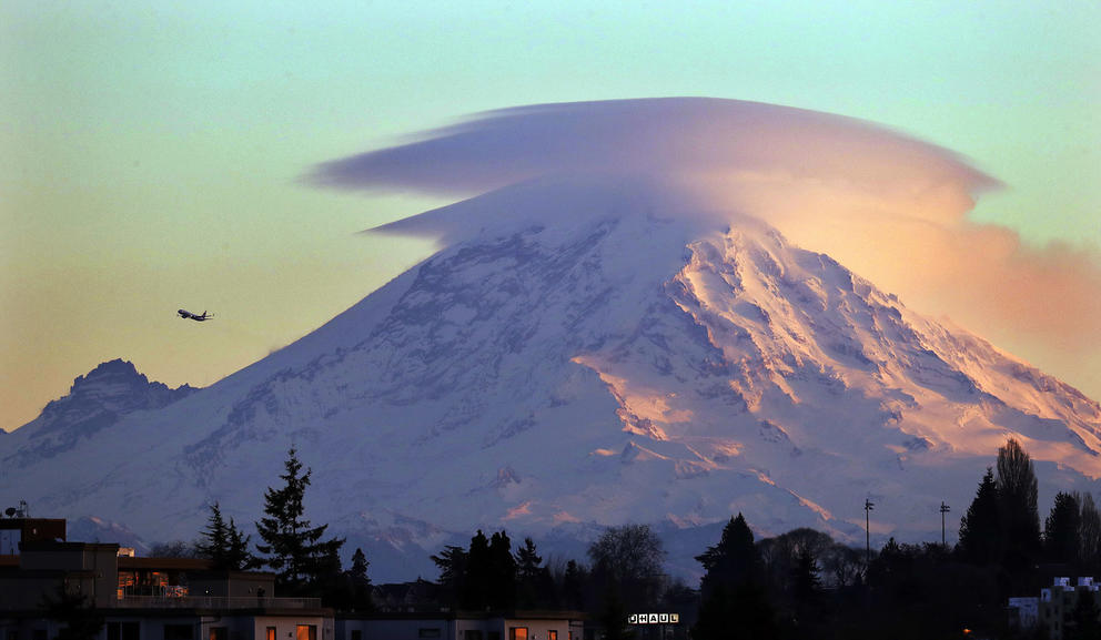
Washington residents observed the hazards of ignorance in real time this week when a news video showing something billowing over Mount Rainier from the vantage of Seattle sent social media into a brief tailspin. A reporter described the video as showing “venting,” insinuating something unusual or even dangerous was happening. As panic spread online, experts tried to clarify that no venting or anything else scary was happening. Instead, the phenomenon was simply a very normal, very benign cloud.
Better understanding our mountains and what to do when legitimate concerns arise can help us manage the stress of living near volcanoes.
“Emergencies come in all flavors, and you never know when they're gonna happen. And so if nothing else, maybe this puts a little bit of emergency preparedness thinking in people's minds,” said Dr. Jon Major, scientist in charge at the Cascades Volcano Observatory of the U.S. Geological Survey, who watched the social media panic play out from his office near Mount St. Helens, another volcano in the Cascade Range that actually erupted in 1980.
Crosscut spoke with volcano experts like Major to gather legitimate volcanic warning signs and advice on how to live well in a land of natural disasters. Bottom line: Don’t let the fear of a very rare eruption consume you — in a macabre silver lining, a volcano eruption is not even the most likely natural disaster you’ll encounter as a Pacific Northwesterner!
So what was really happening at Mount Rainier?
Don’t beat yourself up about being sucked into the social media whirlwind. Even experts like Major had to do research to confirm the white wisp above Mount Rainier wasn’t a big deal. At first he thought it might be smoke from a wildfire near Packwood.
But when he saw the video himself, he did a double-take. “I mean, it sure does, from that vantage point, most certainly looked like there was a steaming plume … emanating from near the summit of the volcano,” Major said.
Then he and a seismologist looked to see if the seismic instrumentation network at Mount Rainier had logged any earthquake-like movement: nothing doing. This is key because when a vent opens in a volcano, rock must be broken and that generates earthquakes. No earthquakes means no eruption.
There was absolutely no indication that an explosion, venting, or anything strange was going on, according to Major. His team called National Park Service colleagues at Mount Rainier to double-confirm nothing was acting up.
When they started piecing together the seismology and eyewitness reports with webcam footage of the mountain taken from multiple directions, they concluded a cloud formation was the explanation.
When warm, moist air escapes through fractured bedrock, or arrives along air currents from elsewhere, it can circulate at the mountain’s peak. Under the right atmospheric conditions, that warm, moist air can condense into lenticular clouds, Major said. Those clouds usually look like mushroom caps but are so reminiscent of UFOs that they are liable to trigger panicked phone calls to authorities.
For whatever reason, Major said, instead of a mushroom cap over the summit, this cloud condensed in a very localized area at the upper west side of the volcano known as Liberty Cap. “From the vantage point of Seattle, it looks very much like a steaming vent,” he said. “If all I had to go on was that video — I would have been really hard-pressed to say something unusual wasn't happening.”
Pacific Northwesterners have confused clouds and steam for signs of eruptions before. Brian Terbush, Earthquake/Volcano Program coordinator for the Washington State Emergency Management Division, said people sometimes post about Mount Baker’s steam plume. It is “pretty much always going,” he said, but we can only see it well on cold, still days. Venting usually isn’t seen at other volcanoes in the area, he said.
What is venting, anyway?
For some people, their mental reference for “venting” is vigorous emissions of gas and ash from a vent in the ground — like what happened at Mount St. Helens in 2004. At that time, magma pushing upward below the crater floor caused the glacier to fracture and dome above it, eventually breaking through with an explosion of steam and ash.
That’s out of the ordinary. However, Mount Rainier does release water vapor when glacial ice or groundwater heats up, and to a lesser degree also releases unpleasant gases dissolved within magma, like sulfur dioxide and carbon dioxide. These escape through outlets known as fumaroles (fyoo-ma-rolls). Gases within magma push up this molten rock, causing eruptions; and rising magma releases gases as it loses pressure on its way toward a volcano’s surface.
But venting fumaroles don’t necessarily mean an eruption is happening, and in the case of Mount Rainier, it’s pretty standard for these outlets to hiss, spew gases, and otherwise announce their presence.
“Even when they aren’t erupting … the conduits where lava has traveled upwards through the crust in the past are more open than they were before the eruption, so these are passages where things that don’t take up much space, like steam and water, can freely travel,” Terbush said.
Scientists monitor this venting as part of eruption surveillance. If they start detecting more venting than normal, or changes in the temperature or composition of the vented gases, they pay more attention.
What are more common hazards at these mountains?
In the Cascades, the most likely dangers you may see are rock slides and glacier collapses, which are “very common” in the summer, Terbush said. These slides can kick up dust plumes that people sometimes call in as eruptions. Debris flows are common in the spring and fall, and can be hazardous to Mount Rainier National Park visitors.
“It’s important to know that if you hear a loud rumbling sound while at the park, get to higher ground, away from the rivers, as quickly as possible,” Terbush said. “But all of these events are not associated with magma movement, and are considered non-volcanic.”
What other volcanic signs do scientists monitor?
Scientists have lots of methods for determining whether volcanoes are acting strangely. The USGS and Pacific Northwest Seismic Network work together to identify these behaviors in three major ways: gas monitoring, seismic activity and ground deformation.
One is a seismometer, which monitors for earthquakes — which happen when magma breaks rocks on its way to the surface. Scientists monitor the size of these earthquakes as well as their frequency and depth, and compare them with background levels to parse whether magma is traveling upward. For instance, the seismic network managed by PNSN identified an early-morning earthquake near Poulsbo on Sept. 8, but one earthquake doesn’t mean an eruption is imminent.
Neither do many earthquakes, in some cases. Some mountains, like Mount St. Helens, see many more earthquakes a month than others like Mount Baker. They have different “background levels” of normal activity.
If scientists notice earthquake swarms, it could be because magma is moving, or it could be tectonic movement along minor faults in the area. There was a swarm just last week for a few hours at Mount Hood, where swarms happen a few times a year.
But scientists use more than one monitoring tool to confirm what is happening. Another is ground deformation, which can happen as magma pushes upward. Using GPS sensors and radar technology, scientists watch for even millimeter-scale changes at the surface. In combination with a series of earthquakes, deformations can help scientists confirm magma movement, Major said.
Mount St. Helens experienced earthquake swarms throughout the 1980s and 1990s. When scientists saw a swarm there in September 2004 over a few days, they assumed it was a similar event. But when another swarm happened a couple days later, with bigger, shallower, more frequent earthquakes, alarm bells for unusual seismic activity went out — and lo and behold, the ground deformed and the glacier cracked. “We went from typical background activity to the first explosion or venting over a span of about a week,” Major said.

Mount Rainier peeks out from clouds in Mount Rainier National Park on May 17, 2019. (Karen Ducey/Crosscut)
How will I find out if scientists see something they’re worried about?
Volcanoes may show unrest prior to eruption over days or even years. Scientists don’t predict eruption dates, but rather offer evolving forecasts as new information arrives. They understand this can be stressful for people living near the mountain.
“We're not trying to hide things from people. If we detect anything unusual going on at any volcanoes in the Cascades, we are going to get that word out,” Major said.
“It's tough. Volcanic unrest in some ways is like getting all the ingredients together to make a meal, then sticking them in the freezer until you’re ready to make them. We’re just unsure exactly when preparing that meal will finally occur,” Terbush said. The actual eruption depends on a lot of physics and chemistry within the magma storage that no one can see.
The USGS is required by law to “issue timely and effective warnings of potential volcanic disasters” per the Stafford Act. Major said scientists could provide weeks to months of notice — or as little as a week, as happened with Mount St. Helens in 2004.
“Most likely in the Cascades, I'd say that if any of the volcanoes [were] to reawaken, probably we would have at least weeks of unrest before something really happened,” Major said.
USGS scientists at the Cascades Volcano Observatory are the best source of information, Terbush said, pointing to how USGS responded to the 2018 eruption of Kilauea’s Lower East Rift Zone.
“They did a phenomenal job answering questions with empathy and compassion related to these facts —we can assume that they will bring these same skills to an eruption that occurs in the Pacific Northwest as well,” he said.
In Washington, counties like Pierce, Whatcom, Skagit and Snohomish all have their own tailored volcano-preparedness resources accessible online.
The best way to keep tabs yourself is by signing up for the observatory’s Volcano Notification Service or referencing the Cascades Volcano Observatory weekly update.
How many volcanoes should I be worrying about?
The Cascades Volcano Observatory where Major works lists eight volcanoes as having the highest threat level potential in our region, meaning they present the greatest risk to people and property. The threat level accounts for both how likely the volcano is to erupt and the possible damage it could do.
Mount Rainier, the tallest volcano in the Pacific Northwest, is a composite volcano: a quintessential cone-shaped volcano that also happens to be active over many tens of thousands of years with the capacity to erupt more than once. According to the National Park Service, Mount Rainier is considered the most dangerous volcano in the contiguous United States.
Even then, for the state’s largest city, an eruption doesn’t automatically mean death.
Eruptions start with explosions of rock fragments. Then, lava — magma at the surface level — flows out, as well as the fast-paced and even more destructive pyroclastic flows — dense, hot flows of ash, gases, and lava blocks moving more than 50 mph. When these flows meet rivers or melt snow, they become far-reaching mudflows known as lahars, which trigger evacuations — down the mountain and as far away as Tacoma — and impact waterways for centuries.
The volcanoes in the Cascades are pretty remote, but lahars can stretch for many tens of miles, and Cascade volcanoes like Mount Rainier have histories of shedding milkshake-like slurries.
“You don't have to have a community close to the volcanoes to actually be at risk from something happening at the volcano,” Major said, calling lahars the volcanoes’ biggest threat. Communities downstream like Puyallup, Sumner and down through to Puget Sound are all at risk because of volcanic mudflows.
To the east of the mountain, ashfall presents the largest threat. Depending on the size of the eruption, ash layers could impede people’s breathing, short out electric grids, interrupt air travel and then settle in inches-thick blankets over an agriculturally important region and get into people’s homes.
Sections of volcanoes can sometimes collapse, leading to avalanches and landslides that devolve into destructive mudflows. About 500 years ago, a lahar streamed forth from Mount Rainier toward what is now Puyallup after a landslide occurred in the absence of an eruption. USGS is building a lahar-detection system to help detect future mudflows.
At least 57 people died in the Mount St. Helens eruption in 1980. The eruption also produced lahars that washed away 27 bridges and almost 200 homes; and ash even caused an aircraft’s engine to fail. Ultimately, the eruption was blamed for $1 billion in damages.
According to the USGS, “The next eruption near a Cascade volcano could upset the lives of hundreds of thousands of people and disrupt many others.”
What is the actual likelihood of a volcanic eruption in the Pacific Northwest?
USGS says the Cascade Range erupts about two to three times a century. Or as the satirical humor website The Needling puts it, “Mount Rainier Will Not Erupt During Your Lifetime, with Possible Exception of Very End.” Mount Rainier most recently erupted about 1,000 years ago.

Visitors hang out near the Paradise Visitor Center at Mount Rainier National Park on June 23. (Amanda Snyder/Crosscut)
There are about 170 active volcanoes in the U.S., most of them in Alaska. There have been at least 120 eruptions of 44 volcanoes in the U.S. since 1980. About 80 U.S. volcanoes have erupted at least once over the past 500 years.
Because these eruptions happen so infrequently, it can make it harder for emergency services to get people to plan for them. But in the good-news category, Terbush adds, the longer it’s been since an eruption, the more time it takes for a mountain to go from a state of unrest to erupting.
This is all a lot to process. How do I manage volcano stress?
Major said volcanoes are something worth thinking about in generational terms. “For the average person living here in the Northwest, I don't think it's worth stressing out about the volcanoes” beyond becoming aware of what the potential hazards in your area are,” he said.
The main message is: know what to do during an emergency. Many emergency measures we take for floods, earthquakes and landslides also apply to volcano preparation.
Communities downstream from the mountain, like Orting, have siren systems in place and train for evacuation. If there are local emergency alerts in your area, sign up for them, because local emergency groups will keep you tuned in to other disasters like floods and fires.
People should also prepare emergency kits. Terbush recommends the “2 Weeks Ready” kit, as it can take emergency services some time to respond in a disaster. Making a kit for your vehicle if you have one also will be useful if you get stuck in traffic or are trapped by a storm, and should include jumper cables. For people in lahar zones where evacuation is time-sensitive, Terbush said, keep a go-bag near your door that will also be helpful during fires or floods.
Lastly, people should make plans for how to communicate with family and neighbors. Know how you’ll evacuate, where you’ll meet up and how you’ll get in touch with each other.
Anything else you can say to calm me down?
Have an accurate appreciation of your risk. An explosion the size of Mount St. Helens in 1980 was a large eruption and not the norm, Terbush said. The vast majority of eruptions are small. Mount Rainier’s largest-known explosion was only one-tenth the size of the 1980 eruption of Mount St. Helens. “So, no, it’s not going to blow up Seattle,” Terbush said.
If equipping yourself with even more information makes you feel better, you’ll be excited to dig into the nearly-700-page USGS document about Mount Rainier, “Living with a Volcano in Your Backyard.”
And if you’re ready to take action and want a roadmap, consider trying WA Emergency Management Division's Prepare in a Year guide. “Just spending an hour a month for a year thinking about and working on these preparation steps will have you significantly more prepared than you were before,” Terbush said.