In the aftermath of the Oso landslide, state and federal agencies stepped up efforts to prevent a repeat of such heavy casualties. Since 2015, the Washington State Department of Natural Resources received more than $13 million in phases from the Legislature – and another $5 million from the feds – to collect and analyze remote sensing imagery.
“Oftentimes, landslides happen where they have occurred before,” DNR landslide hazards geologist Mitch Allen said. “If they’ve happened in the past, it’s likely they’re going to happen there in the future – especially if development or whatever land use is going on impacts those landslides.”
This month, Allen could be found along with fellow DNR landslide geologists Emily Richard and Josh Hardesty tromping through thickets and scrambling over bluffs in Thurston County to check out landscape features they previously flagged on aerial images. The on-the-ground inspections resulted in frequent impromptu debates about whether slope breaks on a hillside and crooked trees indicated slow, benign erosion or a historic slide that should be included in a forthcoming landslide inventory.
The geologists can’t necessarily prevent deep-seated landslides, Richard observed, “but we can try to get people out of harm’s way.”
The DNR Landslide Hazards Program uses lidar (light detection and ranging) data to map active, historic and prehistoric landslides on a county-by-county basis. When mounted on an airplane, lidar uses pulses of laser light to pierce the foliage of trees and bushes and portray the bare ground underneath. The agency has gathered aerial imagery for nearly the entire state, but parsing and processing the raw data is taking years.
So far, DNR has posted comprehensive landslide inventories for Whatcom, Snohomish, King, Pierce, Klickitat and Skamania counties. The inventories are most useful to building permit offices and property developers, but the interactive maps can be accessed by all who are curious online.
“The mapping in these counties covers only 14% of the state, yet an astonishing 34,683 landslides were mapped,” wrote Washington State Geologist Casey Hanell in testimony provided to Congress this winter in a bid for ongoing lidar survey funding.
Hardesty said that in the wake of Oso the geology community has gotten much better at identifying landslide risks and disseminating what they know to decision-makers and property owners.
At the time of the Oso disaster, DNR had one geologist assigned to landslide risk assessment half-time. Now there are five full-time geologists on the case. That team is currently working to complete its landslide inventory of Thurston County while also minding wildfire burn scars in Okanogan County for debris flow risk.

An aerial view of the Oso mudslide in a March 24, 2014 file photo. (AP Photo/Ted S. Warren)
Congress remembers the anniversary, too
In the weeks before the Oso slide anniversary, nearly the entire Washington state delegation in the U.S. House co-sponsored a bill to renew a national landslide research and mapping program created at the U.S. Geological Survey in 2021. The bipartisan House measure, whose chief sponsor is Washington Democrat Suzan DelBene, would continue funding landslide risk reduction at $25 million per year through 2028. A Senate version co-sponsored by Alaska GOP Sen. Lisa Murkowski and Washington Democratic Sen. Maria Cantwell increases the proposed funding to $40 million per year through 2034.
During a House Natural Resources subcommittee hearing on Jan. 31 on DelBene’s bill, the president of the Association of American State Geologists praised the renewed funding for lidar mapping, which he said was producing “revolutionary” results.
“One of the best ways to assess risk of landslides is to find old landslides and lidar has been instrumental in finding such features – even under dense vegetation,” testified Montana State Geologist John Metesh at the congressional hearing.
“In recent years, we’ve seen dramatic increases in extreme weather events. We need to do everything in our power to make sure that communities across the country continue to have the tools at their disposal to be prepared,” DelBene said at the same hearing.
DelBene said her visits to the Oso landslide scene right after the disaster were among “some of the most heartbreaking days” of her time in Congress.
The next big thing at both the state and federal level is to ramp up post-wildfire debris flow monitoring. The pending congressional bills propose that USGS deploy and expand early warning systems for post-wildfire landslides in Western states. Separately, Washington DNR is standing up a small team specifically focused on identifying such areas and warning people potentially at risk.
Local building departments are where the mudflaps meet the road
At the end of the day, federal and state geologists and mapmakers can’t tell property owners where and where not to build. That power generally rests with cities and counties.
The Oso landslide had a particularly dramatic effect on the regulatory regime in Snohomish County. In 2015, the county council roughly tripled the no-build area around steep slopes prone to sliding. For example, development is now prohibited in a landslide runout zone, defined as the area within the distance of the toe of the slope equal to two times the height of the risky slope.
Interestingly, the tougher regulation has had minimal effect on the brisk pace of housing development in the large, growing county north of Seattle.
The county’s Planning and Development Services department estimated that in about 10 cases per year, it requires an applicant to hire a geotechnical engineer and perhaps move a planned house back from the edge of a bluff where it was first proposed.
“It’s not a ton,” the department’s engineering manager Ken Crossman said in an interview.
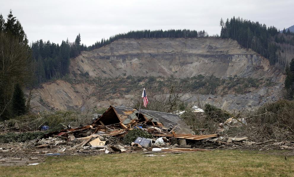
In the 10 years since the Oso landslide, alders and blackberries have sprung up where once there was a muddy gray moonscape. Tree frogs sing in seasonal ponds and hummocks as a steady flow of cars and logging trucks whiz by on state Highway 530, rebuilt across the edge of the slide zone to reconnect the towns of Darrington and Arlington. The massive slide temporarily dammed the North Fork Stillaguamish River, but the river cut a new channel through the blockage within weeks, averting a possible secondary flood disaster.
The buried Steelhead Haven neighborhood will never be rebuilt. Over the past decade, Snohomish County has acquired 163 acres encompassing the slide zone and quite a few surrounding undeveloped properties. The slide memorial takes up only about two acres. A county spokesperson said the rest of the open space will be preserved as conservation lands with limited public access except for the new memorial — to respect the memory of those who perished there.
A few other landslides with major casualties have happened in the U.S. since 2014, including a post-wildfire debris flow that engulfed homes in Santa Barbara County, California, in 2018, killing 23 people and destroying more than 100 homes. Last year, a landslide triggered by heavy rains crashed down from a mountainside outside Wrangell, Alaska, taking the lives of six people including three children.
The Washington Department of Natural Resources reports that non-injury landslides are a remarkably common occurrence in the state. Washington and Oregon are among the most landslide-prone states in the country, according to FEMA data. DNR noted that the state Department of Transportation routinely spends $15 million a year clearing mud and rockslides off highways.
This past winter, landslides spilling across the rails south of Kelso have repeatedly led to days-long cancellations of Amtrak Cascades service between Seattle and Portland. During a legislative briefing earlier this month, the director of the WSDOT rail division pointed to new housing construction and land clearing on the bluffs above the tracks as a probable cause for the instability.
The Washington State Standard originally published this story on March 18, 2024.