Related Stories
")

“Puget Sound will be greatly impacted by a tsunami from a Cascadia Subduction Zone earthquake,” says Maximilian Dixon, hazards and outreach program supervisor at the Washington State Military Department’s Emergency Management Division. “The tsunami will severely damage or destroy most of the maritime infrastructure, including ports, marinas, boats [and] ferries. It will also inundate low-lying areas. With up to five or six minutes of shaking, all of Washington will be impacted.”
Actually surviving this once-in-several-lifetimes event requires rehearsal that goes beyond a single day. For people near the tsunami inundation zone, that means knowing how long it takes to outrun a wall of water as soon as tsunami sirens go off.
The Washington state Department of Natural Resources (DNR) Washington Geological Survey is visualizing that evacuation calculation in a first-of-its-kind collection of tsunami evacuation walk maps. Funded through the National Tsunami Hazard Mitigation Program, DNR's maps show how much time it will take people on foot to evacuate cities in the inundation zone, and the best routes to take, depending on where they are.
The walk maps serve both outer-coastal cities like Westport and inner-coastal cities along Puget Sound like Anacortes. They’re a huge step up from previous maps, says Dixon, who manages federal grants in Washington state that fund initiatives like the walk maps.
Based on walking speeds timed from when the ground starts shaking, the maps include the most efficient routes to high ground from dozens of locations within each city. Beyond aiding in disaster preparedness, they drive home the urgency needed when the Big One strikes our 3,026 miles of coastline.
Designing tsunami evacuation walk maps
Staying alive during an earthquake or a tsunami often necessitates escaping on foot. The U.S. Geological Survey’s evacuation guidance focuses on pedestrians because of copious research into the hazards of driving, says DNR lead project scientist Dan Eungard.
“After a major earthquake event [like] Cascadia, your road network is going to be largely unusable,” Eungard says, noting that liquefaction, ground shaking and landslides will destroy roads and bridges. Where they don’t fall apart, downed trees and power lines may make them impassable. “[In] other major earthquake events around the world, all it took was one car crash and it's blocked a road, and then everyone else couldn't evacuate out off of that road in their vehicle.”
In agreement is Dr. Alireza Mostafizi, postdoctoral scholar at Oregon State University with expertise in transportation engineering. He's unaffiliated with the maps, and has worked on theoretical tsunami evacuation modeling scenarios and behavioral surveys. “According to one of our case studies on the coast of Oregon, vehicular evacuation results in eight times higher mortality compared to 100% on-foot evacuation,” he says.
DNR used the conservative “crosswalk” speed of 24 minutes per mile to account for people with restricted mobility. “Many of them will not be able to evacuate at a higher rate of speed than a slow walk and so it's kind of a baseline for the entire population,” Eungard says.
The walk maps also incorporate information from various agencies’ inundation models, land cover imagery and existing evacuation maps, which DNR fine-tunes with input from local safety officials.
State databases and land covery imagery do “not get down to the level of detail of knowing where all the fences are in the community, or blackberry bushes, or things of that nature,” says Eungard. Only local reconnaissance can tell him which bridges are questionable, or where power lines might fall into routes.
“We can't predict what sort of damage will occur from the earthquake but we can certainly kind of look around before the earthquake and have a guess,” Eungard says.
His team visits locations at least once but largely doesn’t test or time out their routes. In some cases, being on the ground has been critical: Eungard says an initial route model for Port Angeles suggested people walk straight up a cliff, because USGS route-making guidance didn’t note the point at which slopes are no longer considered “walkable.” It wasn’t until he was on the ground in the city that this became apparent.
Hannah Cleverly, deputy director of emergency management with Grays Harbor County, says her department hasn’t time-tested the routes yet but is planning to. Grays Harbor’s largest city is Aberdeen, where more than 12,000 people live in the tsunami inundation zone.
“We are working with our local stakeholders to work toward these assembly areas and these routes. It’s an ongoing project for us. I wish I could wave a magic wand, and it would all be completed in five seconds, but unfortunately it takes a little time,” she says.
Tsunami evacuation on foot is slower in practice
Calculating around slow walk times might seem overzealous, since many people can move more quickly than those with mobility issues. But in a disaster, Eungard says, people may face physical and emotional hurdles that prevent them from going full speed.
“By using that slow walk pace we are hopefully capturing the pace that most of the population will be able to sustain over a distance, including those sort of delays,” Eungard says.
That’s especially true for older residents, who make up a large percentage of Washington coastal population. “We have an elderly population that could have mobility issues, [and] that could slow down the walk time quite a bit,” Cleverly says. “[So] the message that we convey to them is to be prepared to just get out of your house as fast and as easily as you can and don't wait for the [tsunami] sirens to go off. Don't wait after the ground stops shaking for a localized event to evacuate immediately.”
Mostafizi says “milling time”— the period between when people realize an earthquake is happening and when they start evacuating — is the most important survival factor. “Even [a] 10-minute increase in the preparation time can significantly reduce the chance of survival, even … doubling the mortality rate of the evacuation,” he says.
Beyond that, survival is a function of many factors: from familiarity with a route or the ability to follow evacuation signage to the time of day and beyond.
“Considering all of these, it is rather likely to not do the right move if you are not prepared and not familiar with the area,” Mostafizi says, making preventative multichannel communication important.”
Eungard recommends people do timed test runs from home, work and other frequented locations to gauge their pace in ideal conditions. Some outer-coastal communities conduct timed test runs together. Eungard says the Shoalwater Bay Tribe near Westport hosts ‘Yellow Brick Road’ evacuation test events, which have shown “they've been able to make it out within the minimum time specified on the map.”
That’s one reason the state hosts the Great ShakeOut, the largest earthquake drill in the world. “[There’s] a huge tsunami component,” Dixon says. Washington schools in inundation zones have to perform at least one tsunami drill a year, and all schools are required to practice one earthquake drill.
Worst-case tsunami evacuation scenarios
For some populations, these maps deliver a scary message: Without changes to infrastructure, some people in the most vulnerable areas of the coastline likely won’t be able to reach high ground in time to beat wave landfall.
Long Beach’s evacuation walk map shows waves hitting 15 minutes after the first tremors; most areas in town require 45 minutes to evacuate. All of Long Beach's population and businesses are in the inundation zone.
“You kind of do the math,” Eungard says. “These are the locations where we need to think about alternate evacuation options.”
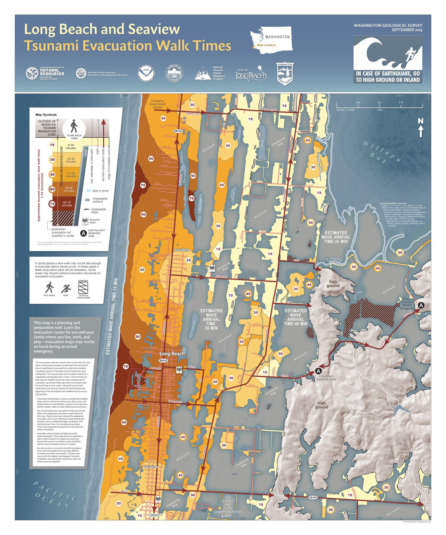
The tsunami evacuation walk map for Long Beach and Seaview in Grays Harbor County. (Courtesy Washington Geological Survey}
One potential option, which Washington pioneered in the U.S. at Grays Harbor County, is vertical evacuation structures: tall, sturdy buildings equipped with extra-deep pilings, thick concrete walls and thousands of pounds of rebar to withstand the rush of a tsunami. The first structure cost $16 million; it doubles as the Ocosta Elementary School gym, and can hold up to 2,000 people.
There are four more structures in various levels of planning throughout Washington, for which groups have applied for Federal Emergency Management Agency funding.
“I'm hoping that is just the tip of the iceberg,” Eungard says. “It really comes down to the local community recognizing that need and pushing for these structures to be built in our communities.”
Mostafizi says his research shows these towers can be crucial tools — when properly designed and located, and accompanied by community training. “If the shelter is not placed with careful consideration of the tsunami inundation dynamics, population distribution [and] capacity needed, the consequences are likely to be catastrophic,” he says.
Dixon says new population surveys show the need for alternate evacuation processes is growing. A recent partnership study with the National Guard, he says, found 43,000 people in Grays Harbor County live in the inundation zone. “Five to 10 years ago, it was 50,000 [people] for all of Washington state,” he says.
More evacuation walk maps on the way
DNR began investing in these maps in 2017, and put out its first round of six city maps this past spring. A second set of four maps was released in October.
When these walk maps will become available for all at-risk cities is unclear. Each walk map takes about one year to put together, Eungard says. The inundation models, maps, and evacuation routes used to build them can themselves take two years and dozens of people to produce.
They also require funding. Dixon says each walk map costs $16,000, while the supporting modeling costing upward of $100,000. So far he has distributed $137,609 in federal funding from the Department of Commerce. “[Funding] is not guaranteed — I have no idea what the forecast is for next year,” he says.
The National Tsunami Hazard Mitigation Program gave Washington state $870,752 for all projects for 2019.
Eungard says it will take his small team years to produce all the maps he hopes to have. “We only have the capacity to do so many, and the data is still being developed for a number of areas … particularly for the inland waterways and Puget Sound,” he says.
“Conceivably we would like to see evacuation maps done for every major community that is exposed to tsunami hazard,” Eungard adds. “It would easily rank into the dozens, at the very least several dozen.”
For inner-coastal cities like Seattle, maritime evacuation risk is the big concern, Dixon says. For the first time last year, he received funding to put together an inner coast tsunami work group and just hired someone to lead it.
“We got some funding this year to put together a maritime mitigation response strategy for the Port of Bellingham and so we're going to start there,” Dixon says “That's going to be a template for us to see how well that goes, and then hopefully everything works out.”