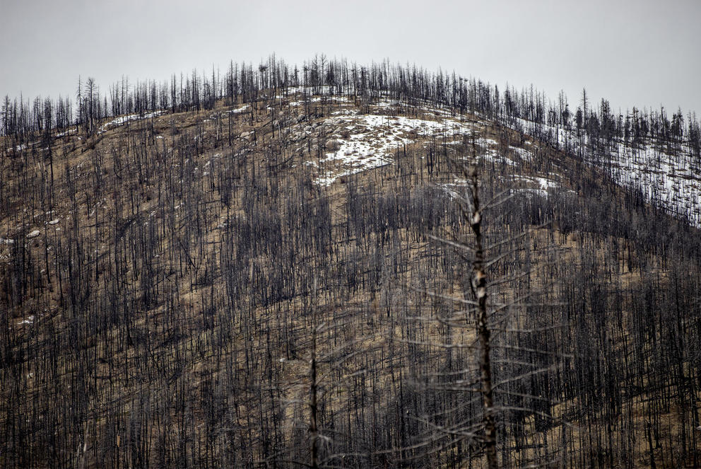
Debris flows are more powerful and dangerous than mudslides and slower-moving landslides: They can sweep away boulders, trees and cars and destroy everything in their path, including roads and homes and the people who live in them. Last year, in Washington’s Okanogan County, two residents were rescued from their home after a debris flow. Another flow destroyed a cabin and sent a foot of water and mud into more than 30 structures. And in 2018, 23 people were killed when heavy rains triggered a debris flow in the burn scar of Southern California’s Thomas Fire.
United States Geological Survey (USGS) modeling indicates that, for perhaps the next five to seven years, there’s a high probability of debris flows in the mountains above Grotto and other communities along the South Fork of the Skykomish River Corridor. The USGS models were originally created using data from drier areas in Southern California, where debris flows have been happening for years after fires, but may be less accurate in Washington’s wet climate — particularly on the rainier side of the Cascade Range. And until recently, there’s been little research on how post-fire debris flows behave in Washington.
One May afternoon, eight months after the fire, a team of researchers made their way up a soot-blackened hillside a few miles from Grotto. Ashy dirt crunched underfoot as they scrambled over and around trees that had been toppled by the fire. They were looking for the right tree to mount a game camera on to document future debris flows. They also wanted to check on the rain gauges they’d installed last fall, not long after the fire, when rainy weather and still-smoldering stumps had made setting up the equipment extra-tricky.
The Washington Geological Survey’s Wildfire-Associated Landslide Emergency Response Team is tracking recently burned sites in the state to understand when landslides occur and how much precipitation it takes to trigger them. “The missing piece is the exact time,” geologist Kate Mickelson said. The weather patterns, geography and vegetation of the Pacific Northwest are different from California’s, and these variations can influence when the earth slides.
In the Northwest, for example, debris flows can occur several years after a fire, while in California, they usually happen in the first two rainy seasons that follow. (Researchers think that might be because tree roots take longer to decay in the Pacific Northwest.) Generally, National Weather Service debris-flow warnings are triggered if a quarter-inch of rain falls in 15 minutes, or if one inch falls in an hour. Sometimes they’re issued for at least the first two years post-fire, either countywide or just for the area near a burn scar. The warning system’s thresholds can be tweaked to reflect the region. But in rainy parts of Western Washington, heavy rain is not unusual, and scientists fear that issuing alerts all the time could numb people to the danger, making them less likely to evacuate.
After 15 minutes of hiking, the researchers found the perfect location for their camera: a standing tree perched just above a likely flow path, a few feet up on a mound of rocks. Finding the right spot is tricky; the tree must be close enough to a debris flow for it to trigger the camera to record, but not so close that the tree (and camera) get swept away. Mickelson and geoscientist Emilie Richard wrapped a strap around the tree’s trunk and mounted the solar-powered camera facing south, then took a few test pictures to make sure it was properly angled.
Game cameras, rain gauges and other tools can help scientists understand how much precipitation it takes to trigger debris flows in Western Washington and help the USGS fine-tune its modeling. Mickelson’s team has set up cameras in five recent burn scars around the state and rain gauges in 11 of them. In some locations, they also installed pressure transducers, devices that measure the water’s pressure on the earth. The devices are drilled into bedrock and can sense the rapid increases in pressure caused by a debris flow.
When the researchers returned in May to install the camera, they also checked on their other equipment. Luckily, all the rain gauges were still in place, so they downloaded the data and changed batteries that were low on juice after the cold winter months. The equipment they installed will monitor the sites for the next five years, noting real-time rainfall — unless, of course, everything gets taken out by a debris flow.
Sitting barefoot in their front yard in May amid lilac bushes and daisies, Grotto residents expressed their concerns. “We have to cross our fingers,” Lorenzo Vasquez said. “We’re screwed for mudslides,” Richard Walther, his neighbor, agreed. They’re worried that debris flows could reroute the creek between their homes and the mountainside, causing flooding or road damage. The Washington Geological Survey scientists hope their work will help residents prepare in the future. “We would like to be able to tell people, ‘This is your peak risk,’” Mickelson said. “We just don’t know that yet.”
This story was originally published by High Country News on Nov. 1, 2023, and is republished with permission.